Wednesday, June 29, 2011

June 28, 2011

June 28, 2011

Start: 888
End: 907

Today we woke up early in an attempt to get to Red's Meadow and then to Mammoth Lakes before the PO closes to pick up packages and then eat copious amounts of food, washed down with some ice cold beer.

The first part of the hiking went quickly up some exposed switchbacks. Unfortunately beyond that point the majority of the trail had some, or was completely covered with, snow. We still made decent time as we passed by Lake Virginia and Purple Lake, crossing a few small creeks. The creeks are interesting to cross. Sometimes you have to search a bit up and downstream to find a good place to cross. Sometimes there are snow bridges that are sturdy enough to cross, but still cause a little anxiousness due to the holes in the snow bridge up and downstream. Other times you walk across the snow and hear water running beneath you without seeing it at all.

We stopped for lunch at mile 900! It's amazing how much faster the last 100 miles went compared to the first 100. The last 7 miles were the slowest for us, primarily because the trail was covered in snow and we were hiking through trees making navigation difficult. Usually there are reliable footprints which can be followed, but it appears that we were the first ones to hike this section today. Fortunately Gangsta Rap has a GPS which made things go much quicker. The last 2 miles were better and we had mostly bare trail to follow through a burned area. I was very ready to be done hiking when we finally got to Red's Meadow. Glad for a couple zero days before hitting the trail again.

We joked all day about how bad the weather was compared to the previous 8 days. There were gusts of wind that must have been at least 10 mph, and then clouds started rolling in in the morning, which turned to a completely cloud covered sky by the end of the day. We heard later that the snow level is going to be 8000' tonight and tomorrow, with the chance of thunderstorms as well. Good thing we are in town, warm and dry!

Misspellings brought to you by iPhone

June 27, 2011

Start: 879
End: 888

This morning we enjoyed a large breakfast before riding back on the boat to the other end of the lake where the trail was waiting for us. For breakfast I had two biscuits and gravy, an omelette with ham, cheese, peppers, and onions, with a side of hash browns and an English muffin. For dessert I had a piece of warm peach pie. What a great way to start the day!

We got back to the trail around 10am and started on our way up to Silver Pass. As we were hiking up after the forst Mono Creek crossing we saw an awesome looking waterfall coming down the opposite side of the valley. Little did we know that we would soon be crossing directly under such a waterfall. I'm not sure what it was supposed to look like during a "normal" summer, but the water on the trail was above my knees and about 20 yards long, not to mention the spray coming from the waterfall itself.

We hiked on a couple more miles and then took a lunch break before making the final push for Silver Pass. The pass was pretty easy to get to. It was a gradual climb on the snow up to a point where we could see Chief Lake and Warrior Lake, both of which were frozen over. The best part of the day was about to come though... Glissading!

We had three glissades on our way down. The third one was by far the best. It was another one of those blind glissades, but this one was even longer than the other. And it was fast and fun! 12 ounce lost her hat, but luckily there was another group just behind us and one of them was able to to reach out and grab the hat mid-glissade and then continue down to the bottom to return it; It was quite a grab.

After the glissading we hiked down another few miles to camp near Fish Creek along with the group from glissading earlier in the day. All in all the hikers include Timex, Gangsta Rap, 12 Ounce, Skinny D, Liz-a-bitch, Funyon, Meow-Meow, and myself.

Tomorrow we make it to Red's Meadow and hopefully a ride into Mammoth!

Misspellings brought to you by iPhone

June 26, 2011

Start: 864
End: 879

Knowing that we had relatively few miles to do to get to VVR today, and we didn't need to be to where the ferry docks until 4:30pm allowed us to get a late start and take it easy during the day.

Early on, just before the Bear Creek crossing, we ran into Wiz, Buttercup, and Wet Smoke again as they were just packing up camp. A little while after the crossing I hiked with Wiz for 5 miles or so and we caught up on some of the adventures we had each had over the past 400 miles. Since they aren't going to VVR, we made a plan to meet up in Mammoth and possibly share a car rental from Mammoth to Quincy for the High Sierra Music Festival on June 30. I don't know exactly what it's going to be, but it sounded like a good time, so I figured I might as well check it out!

The excitement of the day really revolved around 12 Ounce today. She got a little behind everyone else and lost our footprints in the snow so she used her map and compass to chart her course to Lake Edison where we agreed we would meet. At one point during that section of hiking there are 53 switchbacks descending from a ridge to the elevation of the river in the valley below. Unfortunately for her, as she was descending her bear can, which was strapped to the top of her pack, came loose and bounced and rolled down the hill a couple hundred yards. Since the bear can had some of her gear in it on addition to food she had to go down and find it, which she did, only to find herself cliffed out from the switchbacks and in need of an alternate course to the lake. Long story short, she bushwhacked and downclimbed granite on her way down to the lake. She made it there before the rest of us, but due to her alternate direct route, unfortunately she was on the wrong side of the river which was feeding the lake. She ended up having to walk back around, bushwhack some more, and she did eventually make it to the correct side of the lake and in time for the ferry.

12 Ounce is the example of a prepared hiker who knows how to read a map and use a compass. There was another hiker however who had neither a map, nor a compass, who got lost the same day. As of now, he is still lost, but hopefully he'll make it to VVR tonight.

VVR is really where the fun started though. There were about 30 hikers there enjoying the food, beer, and later on the campfire. The first beer is free. The first night camping is free. Everything else was pretty expensive, understandably, since we are in the middle of nowhere. The waitresses in the small restaurant were very entertaining, particularly Olive, and the pie was amazing. Mmmm.

Colin also got a trail name today! Since he is always checking what time it is or our pace or anticipated arrival time, it was decreed that henceforth he be known as Timex.

Misspellings brought to you by iPhone

June 25, 2011

Start: 850
End: 864

Today is the much anticipated Evolution Creek crossing! At Evolution Meadow there is a sign that recommends taking the alternate trail through the meadow if the creek is running high. I guess since this year has the most snow on record since they started keeping records, it's probably best to cross through the meadow. Although the creek crossing was cold, it wasn't any worse than Bubbs Creek and actually was easier than Bubbs.

After warming our feet up, we hiked on down Evoulution Creek toward the San Joaquin River and then up towards Selden Pass. On our lunch break for the day we ended up seeing quite a lot of people including Tal, Goose, Sunflower, Bottle Rocket, Outlaw, Push, Red Blaze, and Half Fast. It's great to see another group out here that are enjoying the Sierras as much as we are!

After lunch we kept on toward Selden Pass and reached the apex at 5:30pm. It was a pretty easy pass compared to others, it did not require use of an ice axe. We enjoyed the view briefly and then headed down the other side to find a place to camp on real ground, not snow or granite. Luckily it didn't take long and we were able to sit in the sun while we cooked and ate dinner.

Just as we were finishing dinner we had a little surprise when Wiz, Wet Smoke, and Buttercup showed up on our small patch of dry land. It was great to see Wiz on the trail again since I haven't seen him since he went home for his sister's wedding a month ago! We chatted for a bit and then they moved onto find a piece of dry ground to call their own for the night. Hopefully we will run into them again tomorrow or in Mammoth in a few days.

Tomorrow it's on to Vermillion Valley Resort (VVR) for some real food! Should be a great day!

Misspellings brought to you by iPhone
June 24, 2011

Start: 834
End: 850

Another early morning start today. We got up around 5am and were on the trail around 6am, about half an hour after Wired, Top Shelf, Blister, and Pine left camp.

As we approached Muir Pass we met two new people, Bert and Ernie, and hiked with them up to the top of the pass, past a false summit. At the top of the pass is a stone house structure built by the Sierra Club in honor of John Muir; it is an awesome little building.

After spending some time up at the top we started descending down toward Evolution Basin to camp before the Evolution Creek crossing, which is supposedly a challenging ford. It was a great hike down off the snow and onto dirt/rock trail again, which is a treat after slogging through the snow for so long.

It's interesting how a hikers perspective changes over time on the hike. It's kind of a 'grass is always greener' situation. When the trail is hot and dry, you long for a creek to cross, or some cold snow to make a slushee. When the trail is snow covered, or there are water crossings every quarter mile, you really want dry trail under your feet.

That being said, every day out here is amazing whether your feet are soaking wet or you have to carry heaps of water. Either way you deal with what the day gives you and make the best out of the situation, like pink lemonade slushees when you are surrounded by snow.

Misspellings brought to you by iPhone

June 23, 2011

Start: 819
End: 834

Water, water everywhere.

After last night sleeping (kinda) on the snow for the first (and hopefully only time) this trip, we dropped quite a bit of elevation out of the wintry wonderland and walked into spring, just at the peak of the thaw. Water was flowing down sheer granite faces, cascading over waterfalls, and charging down the river channel in full force white water. At one point water even flowed over the river's bank and onto the trail. That wasn't the only place where the trail was flooded however. There were many "seasonal" streams that seemingly came from nowhere and ran down the trail at many locations. At one such place, I was walking along in the foot deep water of the trail and almost stepped on a 6" trout. Welcome to water world.

I don't mean to make it sound like the water is a bad thing though, the waterfalls and bank-full rivers are breathtaking and awe inspiring in their beauty and raw power. And it's great to be able to only carry one liter of water for drinking instead of five.

As we followed the Palisades River down to its confluence with the Middle Fork of the Kings River, we got to the point where the ground was more bare than snow covered and it seemed like we walked into an entirely different place. Everything was green, there is grass on the ground, ferns, other ground cover, and even quaking aspen. There were also a few meadows and some wildflowers including paintbrush.

Where the two rivers came together, we turned North and headed up the Middle Fork of the Kings River. It was some of the most beautiful scenery I've yet seen. It's basically how I would have pictured the Sierras in summer would look. We continued up the river until getting to the point where snow started overtaking the ground again and found a dry place to camp with Blister, Top Shelf, Wired, Pine, and Eggman. We are set up 5 miles from Muir Pass which we will do in the morning and then hike another 10 miles to camp just before the Evolution Creek crossing which is supposed to be one of the most challenging of the entire trail.

Misspellings brought to you by iPhone

June 22, 2011

Start: 805
End: 819

Today was an amazing day! We were camped about 2 miles from Pinchot Pass, and didn't want to get there while it was still icy, so we left camp around 7 planning to get there between 9 & 10. We made it up and over the pass quite easily and started down the other side, attempting to glissade, but the snow was still pretty firm and not ideal for glissading.

While we were at the top of the pass, the idea was thrown out to try to do Mather Pass as well, instead of waiting until tomorrow morning. We decided we'd get to our planned stopping point and then decide what to do. We hiked the rest of the day through the snow enjoying the sun and calm conditions that we have been experiencing for a while. When we were nearing our originally planned stoping point we stopped for lunch on a rock outcropping in the middle of snow, surrounded by mountains.

Just before we were going to head out toward the pass, 12 Ounce suggested we make sure we were going toward the correct pass since others we knew (Chili and Pounder) had a 19 hour stretch where they were lost because they went over the wrong pass. It was an excellent idea to double check, because it turned out that we were heading toward the wrong pass, but were only 1.3 miles from the correct pass. Phew! That could have made for an even longer day.

Once we knew where we were supposed to be going, we took off toward Mather Pass. According to Yogi's guidebook, Mather Pass is one of the more difficult passes, which we soon found out. The first part of the pass we ascended vertically up a fairly steep snow slope. After a couple hundred feet, we walked along some rocks and then traversed across another steep snowy slope a few hundred more feet to another patch of rocks. This time we stowed our ice axes, poles and microspikes so we could climb across some more rocks and rock ledges that were barely wide enough to walk across with a backpack. On one side was a vertical rock wall and the other side an extremely steep snow covered slope. After the rocks, we again got out the snow gear for the final few hundred feet of slightly upward traverse to the pass, where we would have to climb up and over a small cornice. This was easily the most intense section of the trail so far; I loved it. What's life without a little excitement!

Once on top of the pass there were some rocks where we could hang out for a moment. Since it was getting late in the day, we started descending and came across the three best glissades yet! The second one was awesome! It started out straight, went over a little lip where the slope got steeper, and then ended out of sight. It was so cool!

After the glissades, we continued to make our way towards Palisades Lake in hopes of finding dry land for camping. Unfortunately everything is covered in snow so we are snow camping, a first for the trip. The stars are amazing as usual, but I think sleep will soon overtake me. What a great day.

Misspellings brought to you by iPhone

June 21, 2011

Start: 794
End: 805

For those who aren't aware, today is the longest day of the year. For those who hike the PCT, it is also known as hike naked day. A day where hikers can be totally free of polyester garments and just that much closer to nature. Of course not everyone participates, which can make for some interesting encounters.

Since the four of us only planned on hiking 11 miles to Twin Lakes, just 2 miles south of Pinchot Pass, we slept in and purposely got a late start. It was fairly cold in the morning and we got a few miles in before it started warming up. When it did warm up, we participated in the hike naked day festivities by donning our birthday suits, along with gaiters and shoes for protection from the patchy snow we were crossing. 12 Ounce and I had a choice encounter with a French couple, who were hiking south on the John Muir Trail, at a creek crossing. We crossed safely, in our finest attire, and then they asked us which way the trail went on the other side of the creek. It didn't seem awkward, but I think they were a little bit surprised.

We continued hiking naked for another couple hours, without running into any other hikers, until crossing a suspension bridge over Woods Creek and stopping for lunch. At which point we had our clothes back on.

After lunch we did a couple more hours of hiking naked and eventually made it to Twin Lakes for the night. Along the eay we ran into Wired, Top Shelf, Blister, Pine, and Eggman. From our sleeping bags there is an amazing view of the last of the sun's rays turning the highest mountaintops pink, and the sky shades of sherbert. What an amazing day.

Misspellings brought to you by iPhone

June 20, 2011

Start: 790
End: 794

So, we didn't wake up as early as we planned, but still woke up around 5:30am. I made a hot breakfast for the first time on the trail which consisted of oatmeal, dried cherries, walnuts, and powdered milk. Believe it or not, it was much more satisfying than pop-tarts.

After breakfast we headed up toward the first pass of the day, Kearsarge (11,600'), so we could actually make it back to the PCT and start heading North again. It wasn't too bad getting up and over the pass, and we made it to the junction with the PCT around 9:30am. After a short break we headed up toward our second pass of the day, Glen Pass (11,970'). According to Yogi, this is the hardest pass of them all. According to us, it was easier than Forester Pass. I think a lot of the difficulty with crossing passes has to do with the conditions encountered during the crossing. If you time it right and have good weather, it'll probably be just fine.

We made it up to the top of the pass around noon and again enjoyed the views for a couple hours while basking in the warmth of the sun and appreciating the lack of wind. While up there we also made slushees with Country Time pink lemonade. It was a delicious way to end our lunch on the pass.

Descending the other side of the pass was supposed to be more dangerous because we had to traverse down along a fairly long steep slope before getting to flatter ground. Because there were already footsteps in the snow and the soft consistency of the snow, we had no problems traversing and made quick work of the upper section. Once we were down below the steep section we got in a couple of glissades on our way to Rae Lakes for the night.

Being at camp early is fantastic and we enjoyed soaking up some more rays before making dinner and getting ready for bed. Tonight's dinner was spinach and cheese tortellini with white wine sausage, Alfredo sauce, parmesan cheese, sundries tomatoes and slivered almonds. Perhaps you can understand why I look forward to dinner each day!

Tomorrow we have an easy day with no passes which I am looking forward to! Living the dream!

Misspellings brought to you by iPhone

June 19, 2011

Nero/Zero. We didn't actually do any miles on the PCT, but did do a couple miles toward Kearsarge Pass.

This morning was pretty much the same as the morning before. We slept in and then ate another large breakfast.

After breakfast we packed up all of our things, including the heaps of food we bought for the next 9 days to Mammoth. I didn't have a scale, but I'm sure this is the heaviest my pack has been to date, probably just over 50 lbs.

Once packed, we walked around Bishop a little, including a stop by Mountain Light Gallery which had some of the most amazing photos I've ever seen; very inspiring stuff. Most of it was taken by Galen Rowell. My favorite photo was one his son had taken at Yosemite Falls at night. There was a lunar rainbow at the base of the falls where the mist was spraying, and then a clear sky with stars up above. Truly a breathtaking scene. There were many other great photos as well, and we commented on how the photos really captured what we have been seeing out in the Sierra but have been unable to capture ourselves with compact digital cameras.

After our stop there we split into groups of two and attempted to hitch back to Independence. It took a little while, but 12 Ounce and I got a ride from a guy named Matt who had recently been divorced and moved to Bishop so he could get away and rock climb more. He had also been to a Buddhist retreat in LA earlier this weekend. It's always interesting getting hitches. Unfortunately he could only take us to Big Pine, which left us 25 miles from Bishop still. So we stuck out our thumbs again and after about 15 minutes got another hitch, this time with a Hispanic father and son, Pedro and Marco. They happened to be hauling scrap metal from Nevada to LA in their semi truck. Yes, that's right, semi. We got to sit on the bed in the back of the cab while driving down the road in a semi. Definitely something I never thought I would do, but so glad for the experience.

After getting dropped of in Independence, we tried to contact a trail angel, Uberbitch, to give us a ride back up to the trail, but her phone was off so we left a message and then tried to hitch. This was definitely the most difficult section to hitch because traffic is very limited going 15 miles from Bishop to the Onion Valley TH. We tried to hitch for a while, but then got hungry so we got some food at Subway, and then got back out on the road to try our luck again.

As we were eating our sandwiches, a man named Kurt pulled up in a pickup truck with trash cans in the back and two dogs. He offered to drive us to the trailhead for $20, but had to go get his other truck first. We happily agreed to pay him for a ride and waited until he came back with the other truck. Little did we know, he did bring back another truck, but still had two dogs with him in the canopy in the back. They weren't small dogs either, they were wolf dogs. We loaded the packs in the back, then the dogs, and then Colin, while Gangsta Rap, 12 Ounce, and I squeezed into the cab with Kurt. It was quite cozy in there.

When we made it to the trailhead we did some last minute preparations and then headed up the hill a couple miles to Heart Lake where we set up camp for the night. We enjoyed the warmth of the sun, then made some dinner, and got in our sleeping bags.

It's great to be back up in the mountains, and I look forward to the string of passes we will be crossing in the next 9 days!

Misspellings brought to you by iPhone

June 18, 2011

Zero day in Bishop.

Today was very relaxing. We slept in and then went to the lobby for the continental breakfast they were serving. We must have looked like refugees both from the state of our clothing and our ravenous appetites.

After breakfast, Colin and Gangsta Rap went about planning the next section of the trail to Mammoth Lake. Due to the number of passes and stream crossings this was critical to figure out ahead of time so we know how many days of food we will need. Based on those factors, we will be averaging 13 miles a day, with some days being longer or shorter depending on the location of the passes and major creek crossings, both of which we want to do before noon.

After planning, we walked to Vons to eat lunch and buy food, and then back to the motel to repackage all the food we purchased in an attempt to get it in our bear cans.

Once that task was complete, we walked over to the Whiskey Creek restaurant for happy hour for more food and some delicious microbrew beer! At Whiskey Creek we ran into Speedbump, Chris, Nicole, Pine, Headbanger, Happy Whale, Punisher, Cowbear, Top Shelf, and Blister.

All in all a great day in Bishop!

Misspellings brought to you by iPhone

Saturday, June 18, 2011

June 17, 2011

Zero day in Independence/Bishop

Ahhh, how nice it is to give the body a break from hiking, especially when that hiking has involved slogging through the snow at elevation.

We slept in, went to Jenny's to eat breakfast, and then packed up our stuff so we could get out on the road to get a hitch to Bishop, 40 miles north of Independence, which is more of a full service town complete with Vons (Safeway).

Standing along the main road through town it took us about an hour to get a hitch. A large crew cab pickup truck pulled over for 12 Ounce and I, and the backseat was so wide that all four of us were able to fit in comfortably. The names of the couple that picked us up are Dave and Joann, who live in Bishop on the reservation. On the drive we told them about what we were doing, much to their surprise. They had heard of the trail but didn't realize that it went all the way from Mexico to Canada, and even asked us where our car was. It's always fun to talk to people who are unaware of the magnitude of thru-hiking the PCT.

Once in town we went to the Ramada where we will be staying tonight and tomorrow, but our room wasn't ready and they wouldn't store our bags for us, so we wandered around the town a little, went to a couple gear shops and a thrift store, and then to Schat's Bakery for lunch.

Wow. What an overwhelming place. Fresh baked cookies, breads, sweet breads, gelato, sandwich bar, jams, jellies, syrups, salts, and more, stacked as tall as me, or higher. It was like a thru-hikers dream come true. Almost overwhelming after the lack of food and people we had seen the past week.
We ate lunch there and bought some other baked goods to eat as snacks the next couple days. If you're ever driving through Bishop, Schats Bakery is a must see and eat.

After lunch we were able to check-in to the room and we hung out there the rest of the day, doing laundry and relaxing by the pool a bit.

Tomorrow we will do some planning and resupply, but more importantly, eat and relax more. What a great place.

Misspellings brought to you by iPhone

June 16, 2011

Start: 784
End: 790

Some days you're the pigeon and some days your the statue. Today we were the statue.

We woke up early again, but had a slower start and weren't on the trail until 6am. Once on the trail we followed a creek, which we would be following most of the morning until crossing a small tributary of the creek and turning east off the trail to head for Kearsarge Pass and a town stop in Independence/Bishop, CA.

This time of year at the 10,000' level the trail is mostly covered with snow. Which can be cool because you can avoid switchbacks, but also make it harder to follow the trail. There are also a lot of streams, some of which are there year round, and others which are seasonal snow melt running down the mountains. These two factors came into play today.

The first trickery happened when we inadvertently crossed the wrong branch of the creek. We thought we were crossing a tributary going to a lake when we were actually crossing Vidette Creek. It was about mid-thigh deep, fast, and cold. We continued hiking for a while after that, but things didn't seem right so Gangsta Rap checked her GPS and sure enough we were now on the wrong side of Bubbs Creek running through Vidette Meadow. Now when I say Vidette Meadow, I mean where the meadow would be if it weren't covered in water. We dropped back down to Bubbs Creek and crossed the shallow part of the creek to the first channel where the creek normally flows. This water was deeper than Vidette Creek so I suggested we use a group creek crossing technique. We all unfastened our hip belts and sternum straps and placed our arms between each others backs and backpacks around the waist/lower back. Colin was upstream followed by Gangsta Rap, then 12 Ounce, and myself on the downstream side. We stepped down into the water which rose to the top of my hipbelt, and were able to make it across fairly easily. We waded through some more shallow water and then crossed the second deep channel together and made our way through more shallow water to get to the other side. All together the water was about 50 yards wide and freezing cold as usual.

When we made it to the other side all of our feet were freezing. Amazingly our luck turned around and there was a group of guys camping on the other side of the creek with a fire going! The saw and heard us crossing and offered their fire to us to warm up which we eagerly accepted. It's in contention for the best bit of trail magic yet. We sat and talked with the guys (Eric, Chris, Micah, Dave, Mark) while we warmed our feet by their fire and found out that they were doing a pre-bachelor party camping trip before heading to Tahoe for the real bachelor party. Before parting they gave us a granola bar each and some trail mix.

After that excitement we continued on and headed up the trail toward the Kearsarge Pass trail. This was fairly steep, but easy to follow and we made it up in good time, but upon reaching the top we got disoriented and it took us a good hour to figure out where the trail junction was and head off toward Kearsarge Pass. It was a long slow couple of miles up to the top of the pass where it was windy and cold, but we made it.

At 12:45 we started descending and the day was much better from there. We again took the opportunity to glissade down some sections of the snow. I can't get enough of it, it's so much fun! We made it down to the Onion Valley Trailhead around 3:20 and waited for a trail angel who was giving rides to and from the trailhead. While waiting Colin was able to get service and we made a reservation in a room at Ray's Den in Indelendence, CA.

The trail angel, Überbitch, gave 12 ounce and I a ride down, and Colin and Gangsta Rap got a ride down with Ray from Ray's Den since we didn't know when/if the trail angel was going to be coming or not.

It's good to be in town, clean, full of food, and in warmer weather! Going to be a great rest before hitting the trail again.

Misspellings brought to you by iPhone

Friday, June 17, 2011

Photos

Camp at Guitar Lake

Mt. Whitney

Sunrise at Mt. Whitney, highest point in lower 48

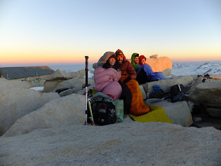
Huddled in sleeping bags at top of Whitney with hut in the background

Top of Forester Pass, highest point on PCT

View from Forester Pass

Proper use of ice axe

Getting hydrated

Thursday, June 16, 2011

June 15, 2011

June 15, 2011

Start: 770
End: 784

Waking up at 4:30am is not normally my idea of a good time, but with what we had coming today it needed to be done. The temp dropped below freezing again last night and I awoke to a tent covered with frost, both inside and out. When I got out of the tent, the full moon was just setting, and it was starting to get light with the impending dawn.

Due to the late creek crossing and freezing temperatures, putting shoes on in the morning was a difficult task. They were pretty much frozen solid, but loosened up with some manipulation. Thy were also very cold to put on, but the thing about the Sierras this time of year is that they are going to get wet with snow or creek crossing anyway, so it doesn't matter all that much. We crossed our first creek for the day at 6am and, in case you were wondering, it was cold.

We were on the trail by 5:30am and headed toward Forester Pass. With the snow being solid in the morning the first miles went quickly, but as the sun rose that began to change and there was a fair amount of post-holing and slower progress. we also got a little off trail, but that's the beauty of snow, you don't have to (or can't) follow the trail most of the time anyway.

We reached the chute up to the pass around 11am and climbed the slope up with trekking pole and ice axe in hand, and microspikes on feet. The slope was a little steeper than a flight of stairs, but there were no stairs, only snow and ice. Luckily others had been up before us so there were some steps already kicked into the snow. We reached the switchbacks and made our way up to the snow chute just below the pass. It was only about 20 yards across the chute, but the slope was steeper than the one we had just come up. Again there were steps kicked in the snow/ice which made things easier, but did not do much to lessen the precarious nature of the situation. It was quite an experience that got the heart pumping and made me have laser-like focus on each step and placement of the ice axe and trekking pole.

We all successfully made it across and continued the last 50' up to the top of the pass. Once on the other side we took a nice long break for lunch at noon and saw Jackass, Dave, Stables, Cookie Monster, Safari, Cowbear, and Punisher while on top of the pass. The view from the lass was amazing, as was the weather. It was comfortable sitting there in shorts and a t-shirt for the entire 3 hours we were there. Again, I can't put into words just how amazing the scenery is here, you just have to see it to believe it.

We headed down the other side of the pass about 1/2 mile and found a great place to glisade. It was so much fun! We dropped elevation quickly and circumvented some of the buried trail before reconnecting a few miles from the pass.

Tonight we are camped near a stream again and it will likely freeze tonight, which means another morning of frozen shoes. On the other hand, we are heading out Kearsarge Pass tomorrow and into Indepedence/Bishop and we will be dining like kings and sleeping in real beds! Mmmmm food.

Misspellings brought to you by iPhone

June 14, 2011

June 14, 2011

Start: 766
End: 770

Today was the best day yet on the PCT. We woke up as planned at 12:50am and headed out from the campsite at 1:20am. The moon was so bright that we didn't need to use our headlamps as we traversed across the snow with Kahtoola micro spikes on our feet and ice axes in hand up the valley to where the switchbacks (snow-covered) began. Since the trail was mainly covered in snow, we followed when we could, and otherwise scrambled up the bare rock sections to get to the next switchback. After a few of these sections, we made it up to where the trail was walkable with only minor amounts of snow and continued up the trail past where the Whitney Portal joined our trail. The views as we climbed up the slope were amazing as the moon slowly set changing from bright white, to yellow, and eventually red right before setting over another granite ridge.

The last 2 miles if the trail to the top were pretty good and went quickly until we ran into one final snow field before the top, which was rocky with little snow. Light and color from the upcoming sun shown on the horizon and we all got in our sleeping bags and waited and watched for the sun to rise as the surrounding mountains began to might up as well, giving us a nearly 360 degree view of snow capped peaks. The exception being east where the mountains drop sharply into the desert with the town of Lone Pine far below.

We hung out and napped a little at the top before starting our descent at 10am. The views were much different in the daylight than they were when we were hiking up in the dark.

When we reached the bottom of the switchbacks we ran into Annie, Jimbrick, Drop Dead, Pellet, and Huff'n'Puff who were hanging out on a rock outcropping. We sat down with them for a while to catch up and then they pulled out the five bottles of wine (in platypus') they had been carrying in anticipation of celebrating at the top of Mt Whitney. Since they didn't make it up that day, they shared with us!

After the wine, we were feeling a bit lackadaisical so back at camp we ate some lunch and rested for a while before heading out around 4 to get in a few more miles to Wallace Creek. The miles went pretty easy since it was mostly downhill or flat. We decided that rather than cross the creek in the morning it would be best to do at night, so we crossed and set up camp. That is some ice cold water, literally.

Everyone was exhausted by the previous two days so we ate dinner and headed to bed so we could wake up at 4:30am in order to get to and over Forester Pass before the snow gets to soft.

Misspellings brought to you by iPhone

June 13, 2011

June 13, 2011

Start: 751
End: 766

Today was a pretty typical day. As usual the views were amazing and we really started getting into the heart of the High Sierra.

The mileage above does not take into account the extra miles we did from Crabtree Meadow to Guitar Lake on the side trail to Mt Whitney. As we made our way up the valley the views just got better and better. I even spotted my first marmot! When we arrived at the lake a little after 7pm, we set up camp and made dinner. As we were eating and enjoying the scenic surrounding mountains and frozen Guitar Lake, the nearly full moon popped up over one of the ridges. It was huge! This is a good thing too because we plan to wake up at 12:50am to hike to the top of Mt Whitney by sunrise. Should be an amazing day tomorrow!

Misspellings brought to you by iPhone

June 12, 2011

June 12, 2011

Start: 731
End: 751

Last night was much warmer than the previous night despite sleeping a thousand feet higher and there was much less condensation. We headed out a little before 7am and started the first climb of the day up to 10500' over about 4.5 miles. The views on the way up were spectacular, as were the vistas from the top. To the east we were able to see Owens Lake bed many thousands of feet below, which is dry because all the water is pumped via aqueduct to the city of Los Angeles. To the northwest we were rewarded with much more pleasant views of the high Sierra, including Mt Whitney. I could have looked at that view all day and not been bored by it. Unfortunately we had to get in more miles for the day, so we moved on.

We then descended 1000' over the next 6 miles and stopped for lunch near a meadow with the sound of frogs croaking in the distance. It felt great to take a break and I had a really hard time getting motivated for the next climb to 11200' and Chicken Spring Lake where we planned to camp for the night. The climb was nice and gradual, so Colin and I were able to take the first half of it fairly quickly. Less than a mile past Trail Pass (leading to Horseshoe Meadow and a hitch to Lone Pine) we started getting into significant snow for the first time. We made another 1.5 miles than stopped at Poison Meadow to wait for the Shotgun Sisters to catch up.

The snow in the meadow, coupled with the granite spires and rock faces, framed with evergreens was pretty awesome. Once we were all back together we made our way across the meadow and towards the lake. Since most of the ground was covered in snow, including the trail, we made a beeline for our destination. The views just kept getting better as we hiked along. A few miles from the lake we had some amazing views if Mt Whitney. We just have 20 miles to do tomorrow to set us up for a pre-sunrise hike up to the top! We also had a great view of the rock walls and scree field surrounding 2/3 of Chicken Spring Lake. I wish I had the words to describe how spectacular it is up here, but I'm afraid the only way for you to know what it's like is to come to the Sierra and see for yourself!

When we finally made our way up to the lake, it was frozen over. How cool is that! The near sheer rock walls capped with snow and overhanging cornices look amazing. Another amazing day on the trail. I would say I don't know how it could get any better, but I know exactly how... Mt Whitney Sunrise Summit in two days! Booya!

Misspellings brought to you by iPhone

June 11, 2011

June 11, 2011

Start: 716
End: 731

Last night, not surprisingly, was quite cold and dewy. I guess that is what happens when you camp right next to a river in an open meadow on a clear night. I awoke at about 5am to a frost covered sleeping bag and fog settled down in the valley. Fortunately when the sun came up it quickly burned off the fog and we were able to get moving.

We climbed from 8000' to 10600' over the next 8 miles and enjoyed views of the high sierra with Mad Hatter. We ate lunch with the view enjoying a reprieve from the mosquitos that attacked us while hiking along Cow Creek, and other seasonal flows.

After a nice long break we descended back to Gomez Meadow where we saw a Basque carving on an old snag of a man smoking a pipe. Beyond the meadow we entered Death Canyon and ran into a few weekend hikers who told us about a nice pool in the creek we just crossed where we could swim. Most of the hikers moved on, but Brent was camped near the creek.

We decided to check out the swimming hole, which consisted of a 3' wide, 4' long pool of 3.5' deep water. Good enough for us, so we stripped down; skinny-dipped, and cleansed ourselves in the cold water. We then lay in the sun to dry off and warm up until the mosquitos made us put clothes back on and find a campsite, which we found 100' away.

While setting up camp, Brent came over and offered us a place by his campfire in exchange for stories of the hike. Having a fire on the PCT is something of a luxury, so after dinner we headed over and joined Brent. It ended up being mostly him telling stories, which was very entertaining. Brent is now 60, but he told us about when he was 18 and went up to Alaska to work for the Forest Service. It turned out they didn't have jobs available, but some guy named McGee who owned a mine offered him a job so he took it. He ended up mining gold and digging out mammoth and beaver skeletons that were stuck in the mud. Very interesting and nice man.

Tomorrow it's up to new heights as we cross 11,000' for the first time!

Misspellings brought to you by iPhone

June 10, 2011

June 10, 2011

Start: 702
End: 716

After two solid days of rest and recovery, the four of us ventured out of Kennedy Meadows and back to the trail. After eating breakfast and getting packed up we headed out at 11am. It was actually pretty hot for a change as we hiked through a meadow of Mexican sage to the Kennedy Meadows CG, and then started to climb up along the South Fork of the Kern River to 8000'. It was the first day where we had water within sight or earshot all day! Gotta love having water all around, especially because that means less weight to carry. This is particularly important because of the extra weight of carrying a bear can and 7 days of food.

We all weighed our packs this morning before heading out and mine was the heaviest weighing in at 45lbs. 12 Ounce had the lightest pack at 42lbs. This made for a slow day of hiking, which was OK since we planned to only average 15 miles a day through Kearsarge Pass where we will exit the trail to resupply in Independence or Bishop.

Tonight we are camped in Monache Meadow next to the South Fork of the Kern River. It is so quiet and beautiful here in the South Sierra Wilderness, the hike is really starting to feel like I thought it would. The fact that there is still a lot of snow in the Sierras has thinned out the herd a bit, with some people heading north to do the rest of the trail and then come back to finish it at the end, and others holed up in Kennedy Meadows waiting for packages to arrive or for more of the snow to melt. Whatever their reasons, it's nice to have more of a wilderness experience.

Misspellings brought to you by iPhone

June 9, 2011

June 9, 2011

Zero day number two!

Today was somewhat similar to yesterday, but slightly more productive. Maps were scrutinized, and food stuffs reviewed and placed in bear cans in preparation for the real beginning of the High Sierra and bear country. The plan is to push through from Kennedy Meadows to Kearsarge Pass and resupply in Independence or Bishop. During this stretch we will also be making a side trip to summit Mt Whitney!

A former thru-hiker, Huff'n'Puff, showed up today and gave us a rundown of the conditions from Kennedy Meadows to Kearsarge Pass since he had just done the section as part of an advanced snow course. It sounds like it will be interesting the next while through the high Sierra, but I am looking forward to getting into the snow, creeks, and alpine lakes!

After our preparations were complete we went down to the South Fork of the Kern River to hopefully go for a little swim and hang out by the water. We had trouble finding a calm slow section to go swimming in, but Tom gave us a ride upstream a little ways and dropped us off where he said he would usually go to swim. It turned out that the water level is higher this year and moving faster than usual, making the location less than ideal for swimming, and more likely getting swept down the river a ways. I don't mean to make it sound crazy, it just wasn't good for swimming. Instead, Speedbump, 12 Ounce, and I decided it would be a good idea to try floating down the shallow, rocky river on the foam sleeping pads we had brought to lay out on. It was a bumpy ride, but we avoided rock/water enemas, and rode down only a short way before getting out and walking the remaining way back to the bridge where we found others hanging out. Unfortunately the trip was not without casualties as I lost my flip flops down the river. On the plus side, they were from the dollar tree, but I feel bad about where they will end up littered along the side of the river somewhere. I just hope that they are together somewhere and someone else can make use of them down the line.

Misspellings brought to you by iPhone

June 8, 2011

June 8, 2011

Zero day in Kennedy Meadows today!

Last night was a little bit interesting. Right as we were getting in our sleeping bags preparing to cowboy camp, one of the guys who has been working at the store grill (Climber) told us that we needed to move because we were actually on Tom's neighbors land and the neighbor isn't all that friendly to thru-hikers. He told us he was sorry to make us move, but it was probably going to be better than waking up with a gun in our face. We agreed and gladly moved.

Other than what happened last night it was a rather regular day filled with laundry, sitting on the porch, eating, drinking, and hanging out with other hikers.

Only a few new hikers made it in today, including Ethan, who I haven't seen since Warner Springs at mile 110. I talked with him and a couple of the other guys he was hiking with including Glide, Turbo, and Mr Furious. It was good to catch up with them before they headed out for Lone Pine.

Glide was by far the most interesting of the bunch. Part of that may have had to do with the fact that he drank about 6 beers while on the porch. One of his comments was regarding Pinyon Pines which he said reminded him of juniper. Everyone at the table kind of looked at each other with quizzical looks because they really are not that similar at all. He also thought that the human heart weighed one ounce. Very interesting fellow.

The rest of the day was spent napping, eating dinner at the store, and then heading back to Tom's place where Colin, Gangsta Rap, 12 Ounce, and myself had secured beds in some of the many trailers scattered across the property. Apparently some of the trailers he bought, while others were basically given to him. As one of the donation boxes says, "Kennedy Meadows: where hiker trash meets trailer trash." Couldn't have said it better myself.

Misspellings brought to you by iPhone

June 7, 2011

June 7, 2011

Start: 681
End: 702

Today we successfully made it to Kennedy Meadows! It was a cold morning and we were on the trail by 6:30. We hiked up two miles to a spring, grabbed a little more water, and then continued up the hill to about 7600' before descending to 5800' at a creek crossing. I had been feeling a little antsy so I decided to run the downhill section and got to the creek, 12 miles from where we camped, by 10am. I ate a little lunch and waited for the others to get to the creek in Rockhouse Basin before moving on ahead the remaining 9 miles to the Kennedy Meadows general store.

I was enjoying the scenery of the hike when, after a couple miles into the section, a racer snake startled me when it slithered it's way across the trail right in front of me. After that I decided to be more vigilant of the trail in front of me so that wouldn't happen again. Of course that vigilance didn't last and less than a mile later I was hiking along, just past a little Mexican sagebrush shrub on the right side of the trail, when I heard the distinctive "move your ass" sound of a rattle snake in that bush. That got me to jump a little bit and I really was more aware of what was going on near the trail after that.

A couple miles later the trail came to the Kern River, the first real body of water of the hike! The remaining miles of the trail generally followed the river until the road to the store in Kennedy Meadows. It is one of my favorite parts of the hike to date.

At 1:25pm I came to a trail register just before a road, signed it, and thought because it was so early I must be at mile 700 with another 2 miles to go before the road to the store. Turns out I was hiking faster than I thought and that was the road to the store, which I found out a couple more miles down the trail when I got to the campground at mile 704.something. So I got a few bonus miles! I eventually made it to the store and enjoyed a lot of food and some beer with the other hikers hanging out there.

After dinner we headed to a trail angels property (Tom) and are camping on his land for the next couple nights. More on that tomorrow!

Misspellings brought to you by iPhone

June 6, 2011

June 6, 2011

Start: 656
End: 681

Today was mostly a solitary day. I walked with 12 ounce and Gangsta Rap the first couple hours through the cloud/fog at about 7000' before we descended to lower elevations, less wind, and slightly warmer weather.

From 9 to 11:40 when we got to the next water source I hiked alone. I ate the usual lunch with Colin, Headbanger, Nicole, Chris, and Happy Whale. After lunch at 12:45 I set off on my own again for the next 11 miles to the next creek for water and a BLM campground just up the road.

Along the way I smelled a few trees. I know that may sound strange, but hear me out. Gangsta Rap graduated from UW with a degree in forestry and enlightened us that Jeffrey Pines smell like cream soda. The trick is that you have to find one that has some nice deep grooves in it's bark, preferably in the sun. I encourage you to try it sometime. I believe Ponderosa Pines are similar as well.

Walking alone affords lots of time to think about many things. One of the things I thought about today was how much of my food has disappeared since the resupply in Tehachapi. This is both a bad and a good thing as you can imagine. On the one hand my pack is much lighter than it was a few days ago which is totally awesome. On the other hand, I have been having to ration my food so as not to eat too much each day and run out of food before Kennedy Meadows. This section I have never really been full, but not starving either. Just a little hungry most of the time. I guess it's better than being mostly hungry a little of the time? Maybe not. Either way I am really looking forward to burgers and other hot food at Kennedy Meadows.

Misspellings brought to you by iPhone

June 5, 2011

Start: 632
End: 656

Last night as a group we decided we would wake up at 5:30am to get an earlier start than we had been getting. Our alarms went off in the morning and we woke up. Gangsta rap poked her head out of her tent, followed by Colin, and raved about the pink sky as the sun was about to rise. About five minuets later, gangsta rap looked out again and told everyone they needed to see it. Begrudgingly I opened my tent and looked out to discover the pink clouds of the sunrise along with, not one, but two rainbows. Yes, that's right, a sunrise double rainbow. At that instant we all knew it was going to be a good day.

We hit the trail at 6:30 and hiked all morning taking few breaks. It was pretty easy hiking all day, coupled with the fact that it was cool, made it an ideal day for hiking. We had heard rumors that there would be trail magic at Walker's Pass so we all wanted to get there for lunch to hopefully supplement what we individually had for lunch.

We got to the CG at Walker's Pass at about 2:30pm and there was indeed trail magic! Momma Moab and her son Jayhawk, as well as another lady, were there with cold drinks and little food after 45 other hikers in the past three days had already been through and eaten most of it. Nonetheless we were stoked about the situation and took advantage to the cold beverages.

We got back on the trail at 5 to do a few more miles before setting up camp for the night. We made it about 5 more miles and are currently camped on a ridge where there is a little wind, partially blocked by a few pine trees. Another perfect night for cowboy camping! And two more days to Kennedy Meadows!

Misspellings brought to you by iPhone

June 4, 2011

Start: 610
End: 632

The first half of the day we hiked primarily east, over and down a ridge, out of the burn area, through some pines, and back into some desert. The clouds have been looking threatening all day, but things started looking better as we headed east.

We stopped for lunch near a Joshua tree, which really provided no shade since the sun was directly overhead. We made a good effort at finding shade and waiting out the warmest day we've had in about a week. The cloud show that has been put on has been spectacular all day, but could mean that we are in for a wet night or day tomorrow.

Around 3:45 we packed up and headed down the trail a few more miles to the next water source. When we got there the cache had many bottles of water, but only about 7 liters of water to share between the four of us, which needs to be enough for dinner tonight plus another 13 miles tomorrow. Each of us had some water left, so it shouldn't be a big deal despite the moderate climb from 5400' to 7000' first thing tomorrow.

We set up camp at the base of the ridge we are ascending tomorrow, right on or near the trail since it is the only flat-ish ground.

After setting up our tents in anticipation of rain, we made dinner, which was great as always. I really look forward to meal breaks, particularly lunch and dinner because with the bigger meal, we also get a longer rest break. Tonight was couscous with tuna and some random seasonings. I am definitely building up some hiker hunger this past few days. I have been having to be more aware of how much food I am eating each day more so than I have had to yet. I am not completely full after meals, but fairly well satisfied. It just makes the anticipation of a giant burger at Kennedy Meadows that much greater and I'm sure tastier than it otherwise would be.

I climbed into my tent fifteen minutes ago, just in time for it to start raining a little. Hopefully it won't be a really wet night, but I guess it's better to have rain at night my while sheltered in a tent than during the day while hiking.

Misspellings brought to you by iPhone

June 3, 2011

Start: 587
End: 610

Today was a great day! The wind finally calmed down and we walked through some beautiful pinyon and Jeffrey pine forests. It reminded me a lot of central Oregon where the ponderosa pines grow. We got through the first 15 miles of the day to the next water source by 1:30, with only a minor detour on a road that appeared to be closed, but ended up being the right way.

We took a nice long break near the spring and ate another amazing lunch. After lunch we wanted to get in about 7-10 more miles so that we only have to do about 22 miles a day for the next 4 days. After 8 more miles we found a nice camp spot in the middle of a burn area amongst little purple and yellow flowers. For the majority of the day it has really felt like we are now officially in the Sierras due to the presence of more pine trees and granite outcroppings.


So, as you may imagine, there is plenty of time to talk about a lot of things, but most conversations usually lead back to either food or poop. This next little anecdote is about the latter. One of 12 ounce's students in SCA came up with a staged description system to let other people know how urgently you need to go without being blatant about it. There are 5 stages, each can have a plus added to the rating depending on urgency. Without further ado, the stages...
Stage 1: you just pooped and you couldn't poop even if you tried.
Stage 2: you could squeeze something out, but it isn't urgent.
Stage 3: you will need to go by the end of the day.
Stage 4: things are moving and you need to go in the next hour or two.
Stage 5: there is no time to wait and you must drop your bag and dig a cat hole in the next 5-10 minutes.

To accompany the stages, there is also a rating system for the experience during the poop.
1: just normal, nothing special about it
2: an especially good poop
3: there is an amazing view during the experience
4: you have an animal sighting while in process
5: same as 4 and you make eye contact with the animal
6: same as 5 and then the animal also poops

Enough about that for the day, it's looking a little bit like rain tonight so we are cowboying but also set up our tents as emergency shelters in the event it starts raining. Here's hoping for a dry night!

Misspellings brought to you by iPhone

June 2, 2011

June 2, 2011

Start: 568
End: 587

So, I should mention that I have a trail name, although there isn't a story to go with it. My name is Stag. I'm going with it for now, we'll see if it sticks! Also, 12 ounce, Gangsta Rap, Colin, and I have named ourselves Team Legs. I would say we all have great legs, but that would be presumptuous and is really in the eye of the beholder.

Our campsite last night was great! Quiet, no wind, and fairly warm. It was a bit of a late start, and once we were out of the protection of the trees it was windy and cold. Despite being cold and windy it was a beautiful day. As we climbed north, away from Hwy 58, we were treated to magnificent views east, south, and west, including Mt Baden-Powell which we bagged coming out of Wrightwood many miles ago.

We hiked 14 miles from our camp, to the next water source for a lunch break. It was a pretty slow and relaxed pace partially due to the fact that our packs are weighed down with 6 days of food and we were each carrying 3 liters of water each. Lunch was a delicious combination of crackers, cheese, and pepperoni, as well as some rice crackers, mike n ikes tropical typhoon, and Gatorade. All of which was purchased at the dollar tree in Tehachapi. Thank you Dollar Tree.

The waterless stretch after lunch was even longer, and we planned on dry camping, so I carried 5 liters of water in order to have enough for drinking tonight, cooking dinner, and the remaining miles tomorrow to get to the next water source. We only went another 5 miles after lunch before finding a nice little campsite with plenty of flat ground and a fire ring! The fire ring sealed the deal, so we set up camp at 5:30 and hung out in the sun for the next couple hours. For dinner we had what we termed "epic meal time" because of all the delicious food we packed in and were about to prepare. Colin cooked up a pasta side packet and then added salmon and artichoke hearts. The shotgun sisters made whole grain noodles with pesto and salmon with fresh pesto from the store, not the packet mix. I had whole grain pasta with pepperonis, artichoke hearts, parmesan cheese, granulated garlic, salt, black pepper, and cayenne pepper. We each sampled each others and everything was delicious.

We then started to build a campfire when Speedbump, and a little later Barney, joined us at our camp. We then sat around the warmth of the fire and recounted the happenings of the past few days. One of the highlights was Speedbump recounting how some lady in Tehachapi pulled over in her car, asked if he wanted a hot meal, to which he said yes, and then she proceeded to drive him to a Salvation Army soup kitchen. He decided to just go along with since he was in need of a hot meal anyway. Just goes to show how much hikers resemble the homeless... Because we are.

Misspellings brought to you by iPhone

June 1, 2011

Start: 563
End: 568

We woke up this morning in the middle of a cloud. We hiked down the 3 miles to the highway and attempted to get a hitch to Tehachapi. Along the way we met up with Balls and Sunshine (11 year old) and the six of us tried to get a ride along the highway for about an hour. We split up and ended up getting rides in fairly quickly.

Once in Tehachapi we went to Denny's for breakfast and discovered we were there in the middle of Baconalia! A celebration of bacon. For dessert at breakfast four of us split the bacon maple sundae. Not that good, just like you were probably thinking.

We spent the rest of the day in town going to the PO, grocery shopping for the next 6 days to Kennedy Meadows, and eating more food and drinking a few beers.

We then got a ride from another patron of the Don Perico's back to the trail and hiked a couple of miles until we found a good place to camp.

Nice relaxing day and night!

Misspellings brought to you by iPhone

Tuesday, June 14, 2011

Mt Whitney

Sorry I haven't posted for a while, but cell service had been a bit sketchy. I am currently on top of Mt Whitney! Woke up at 12:50am, and summited in time for sunrise.

Sunday, June 5, 2011

May 31, 2011

Start: 541
End: 563

Today was another epic day in the Mojave desert. 12 Ounce, Gangsta Rap, Colin, and I woke up early at about 5am in an attempt to avoid hiking in the heat of the day. We didn't actually start hiking until 6:15, but still a much earlier start than yesterday.

We climbed about 2000' during the early part of the day, and then around 10am we came upon the first of the windmills. It was a very strange thing to come around the corner, and peaking over the hill are giant windmill blades.

We stopped for lunch at Oak Creek, just before Willow-Springs Road, and enjoyed our last trail lunch before resupplying tomorrow in Tehachapi. We also lay out in the sun for a while, enjoying the warm California sunshine, and talked about how great it is to be on the trail. Although we are in the Mojave desert, it was fairly cool, with a high in the mid-70's; we couldn't have asked for more perfect weather for this section.

After our break, we set out to do a few more miles and then camp just shy of Hwy 58 where we will be hitching a ride into Tehachapi. It was a hot and windless section, despite being in the midst of a field of giant wind turbines.

About 4-5 miles up the trail we found a nice place with a great view of the coming sunset. We got to camp early enough that we were able to enjoy the sunshine some more before setting up camp and making dinner. From our camping spot we can see many windmills, Tehachapi in the valley to the west, and across Hwy 58 the southern end of the Sierras!

Misspellings brought to you by iPhone

May 29, 2011

Start: 493
End: 518

Today was a bit of a wild weather day. It all started at 1am when I got up during the night to set up my tent because it had begun to rain. In the morning, we got up around 6:15am and packed up our wet tents and hit the trail in full rain gear because it was cold and a bit windy.

Around 9am, much to everyone's surprise, it started snowing! In Southern California at the end of May. Crazy weather! It ended up snowing off and on the rest of the day and never really warmed up.

About an hour after it started snowing we hit a big milestone: 500 miles on the trail! It's crazy to think we have already hiked that many miles, and how quickly the time is passing. The second part of the day was nice and easy since we were descending out of the mountains down into the desert again, and through the western edge of the mojave desert.

The end of the hiking day ended up being at a place called Hikertown. It is a very interesting place. Essentially it is like a mini western town set from a Hollywood movie. There are multiple buildings with various names, each with beds, futons, or couches which can be used by hikers. Hikertown is owned by a man named Richard and is looked after by the caretaker Bob. Also in attendance from Richard's staff was Jeff, who was in charge of taking care of Richard's 23 cars, including two Ferraris and five Rolls Royce. They were all interesting people, but the most interesting by far was Jeff.

Balls' and Sunshine's family was g them at hikertown and generously made tacos for the hikers staying there.

After dinner we heard some stories from Jeff about his wife, kids, the two times he went to jail, and some memorable quotes. Two of the quotes from that memorable night were:

"I'm not racist, I just hate Mexicans."

"I don't care if they wear a badge or not, they can still take an ass whoopin'."

I will leave it at that.

Misspellings brought to you by iPhone

May 28, 2011

Start: 478
End: 493

Slept in until 8am, and headed down from the manzanita grove in the backyard, where I was camped, to the house for pancakes and coffee. Some other hikers had arrived in the morning, including the shotgun sisters.

After breakfast, Annie, Kylie, and I talked about what we were going to do for the day. There was the option of slack packing 8 miles from up the road, back to Casa de Luna, or just heading out and getting down the trail toward homegrown, 40 miles away. The shotgun sisters and Colin planned to head out, but Annie wanted to stay for the memorial day weekend festivities, which involved Hershey syrup wrestling and other activities. I was a bit concerned that I was going to get roped into wrestling, so I definitely wanted to get out of there to make sure that didn't happen. Kylie also wanted to leave, but as Colin, 12 ounce, Gangsta Rap and I piled in the van for the trail, Kylie couldn't get ready quite quick enough so Terry was going to take her on the next trip. Unfortunately for Kylie, Terry had other plans and she ended up slack packing the 8 miles with Annie, Drop Dead, and Tumbleweed. I'm glad I was able to escape the Casa de Luna vortex.

We got to the trail at 11:30 and the first few miles hiking today were slow and miserable. It seems like every time coming off a zero day it takes me about 5 miles before I get back into hiking mode and remember why I'm out here.

The scenery today was much the same as it was the previous hiking day. The hills we are hiking through are covered in scrub brush and small trees, and as I look out across the hills I am reminded of the jungle of central America, minus the hot temperatures and horrendous humidity. It has been relatively cool all day, even overcast at times with a cool breeze.

Around 4:30pm we stopped at Maxwell Guzzler to get water, which the water report said was brown due to pine needles being in it, but otherwise good to drink. As I was filling up my first bottle I noticed that there were a number of very small little swimming creatures at the bottom of the bottle. Since we all needed water, we figured we would just double the treatment dose in hopes of killing off any potentially harmful bacteria and critters. During the water filling and treatment episode, we decided that the pine forest where we currently were would probably be the best place to camp without having to walk another 10 miles.

The little swimming guys in the water were still swimming after they should have been dead, so I boiled the water for a couple of minutes before adding my tortellini to the boiling water. Tonight for dinner I had cheese tortellini with sun dried tomatoes, garlic powder, salt, pepper, cayenne pepper, salami, and parmesan cheese. One of the best trail meals I have concocted to this point.

After dinner it was getting colder and a bit dark so we crawled in our sleeping bags. As I turned on my phone I got two text messages and a voice mail all regarding a forest fire North of where we were. I called the Anderson's house to get an update and apparently there is/was a 100 acre fire that is now contained, and shouldn't cause a disruption to thru hikers. Nothing quite like a little excitement on the trail!

Tomorrow it's on to hikertown, but I'm not really sure what is there other than a hostel. Should be an interesting time!

Misspellings brought to you by iPhone

May 27, 2011

Zero day today at Casa de Luna. Joe made some delicious pancakes for breakfast, and then just spent most of the day lounging around the house, watching some TV, and eating more. We even witnessed a high speed chase through LA on TV! Better than a movie. There is a girl named Rambo here who has an amazing voice and played/sang some amazing songs around the fire pit at night. Great zero day!

Misspellings brought to you by iPhone